| Miscellaneous Images |
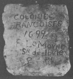
| This small tablet, made of marble, was discovered at the site of Fort Maurepas: "Colonie Francoises, 1699, Pe. LeMoyne Sr de Ibvle" |
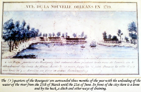
| With thanks to Don Bourgeois for this image, "View of New Orleans, 1719" ... Don very kindly translated the image description: "The (?) quarters of the Bourgeois' are surrounded three months of the year with the unloading of the water of the river from the 25th of March until the 21st of June. In front of the city there is a levee and by the back a ditch and other ways of draining." |
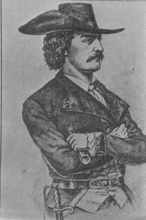
| Jean Lafitte, pirate and hero of the Battle of New Orleans. Contrary to popular belief, Lafitte did not take part in the battle itself, though many of his men, including one of his brothers, Dominque You, did. Lafitte served as a guide for Gen. Jackson and, also, provided much needed supplies. |
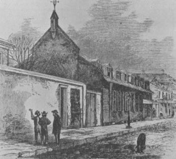
| On the night of January 7, 1815, the eve of the final Battle of New Orleans, nuns, relatives and friends of soldiers prayed at this old Ursuline Chapel. This building, built for the nuns by Don Andres Almonester y Roxas in 1787, was incorporated into a school on the grounds of the old Ursuline Convent, which still stands. |
| The first St. Louis Church, the first permanent church in the settlement in New Orleans, as it appeared in 1730. Started in 1724, it was completed in 1727. French Governors Perier, Bienville, Vaudreuil and Kerlerec, as well as, Spanish Governors Unzaga, Galvez and Miro worshipped within its walls. The remains of the faithful were brought through its doors enroute to the first cemetery on St. Peter Street. The church and most of New Orleans burned to the ground in the great fire of March 21, 1788. This drawing was made from Adrien de Pauger's architectural plans, which are in the French National Archives in Paris. |
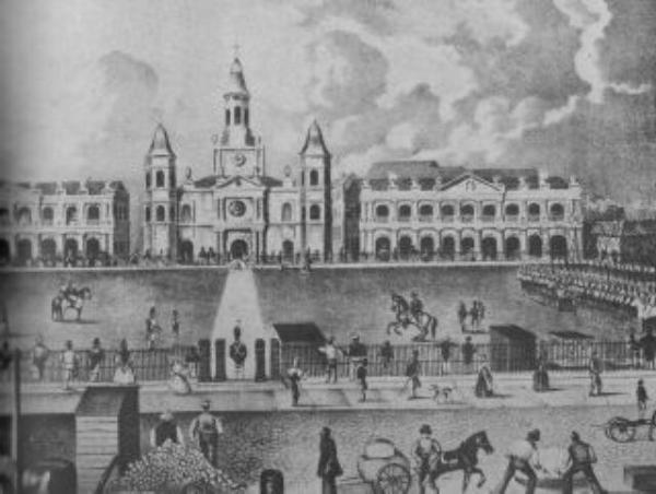
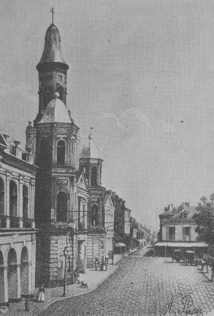
| Gaston de Pontalba drew this sketch of the Place d' Armes in 1849; left to right, the Cabildo, St. Louis Cathedral and the Presbytere. Notice the mansard roofs of the Cabildo and Presbytere, added since the 1845 drawing. |
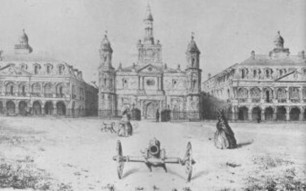
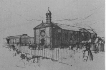
| Sketch of the Place d' Armes (later called Jackson Square) in 1845, by Thomas Williams. At this time it was a parade ground, note the soldiers drilling. |
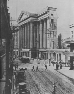
| The second St. Louis Church at the Place d'Armes, a gift of Don Andres Almonester y Roxas. Construction began in 1789 after the great fire of 1788 destroyed the original church. It took five years to complete and the church was dedicated as a cathedral in 1794. Another fire had destroyed 212 buildings just a few weeks before the dedication, but the new cathedral survived. It was used until 1849, when it was determined that a new building was needed. That is the building which remains today. |
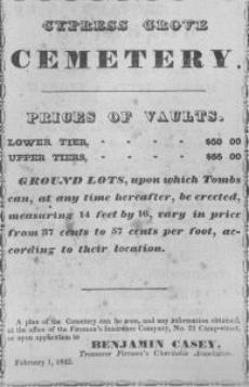
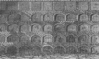
| Left: Cemetery advertisement, "Lower tier...$60.00; Upper tier...$65.00; Ground lots upon which tombs can, at any time hereafter, be erected, measuring 14' x 16' vary in price from 37 cents to 57 cents per foot, according to their localities. Benjamin Casey, Treasurer, Firemen's Charitable Association, February 1, 1842." Right: Sketch of typical wall vaults found in old New Orleans cemeteries. Lafayette #1 was built in 1833, St. Joseph's in 1850, Lafayette #2 in 1853, Carrollton in 1848 and St. Vincent's in 1850; below Canal, besides St. Louis 1 & 2, St. Louis #3 was built in 1856, St. Roch in 1868. |
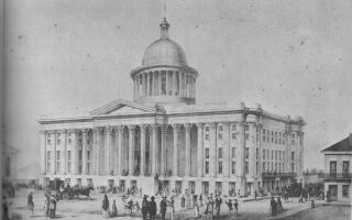
| Left: One of the most talked about buildings in the city, the St. Charles Hotel, shown in this 1842 sketch, was the center of business and social life in the American section in the 1840's; fire destroyed this building in 1851, along with several other nearby buildings. Right: The hotel was rebuilt and the second building was destroyed by fire in 1894; photo at right shows the hotel after the 1894 fire. |
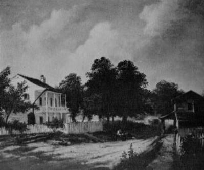
| House on Grand Route St. John: This house was situated on the last leg of the Bayou Road that led from New Orleans to the settlement of Bayou St. John, which had become an important small port and settlement in the late Spanish period. Before other canals were dug, supplies coming to New Orleans via the Lake Route, through the Rigolets and Lake Pontchartrain to Bayou St. John were unloaded at Port St. John and carried to the city over the portage road. The portage road was the earliest path from the Lake to the River, and has been used since time immemorial by the Indians before the French began exploring the area. With the coming of the French colonizers it became the main road for bringing supplies and people to the new settlement on the Mississippi. During the late 1700's and first half of the 1800's, it became the fashionable road of the area, along which many lovely homes were built, most of them two-story plantation type homes. This area, along with Gentilly, was one of the earliest and most fashionable suburbs of New Orleans. It was so early that concessions of land in this location of Grand Bayou de St. Jean (as named by Bienville) were granted to settlers as early as 1708. In 1718, when the future Nouvelle Orleans could boast little more than a rude shack serving as a temporary shelter for the Commandant, Jean Baptist LeMoyne Sieur de Bienville, settlers were established along the banks of Bayou St. John. |